The Calder system was an inhabited planetary system in Sector 2158, Beta Quadrant.
Components
Stellar system
This was a binary system with a unnamed star and its companion. They were an A-type star and an F-type star.
Planetary system
This system had 4 planets. In the system's habitable zone, there was the inhabited world Calder II.
History
In the 2360s, this system was home to a Federation science station and historical preserve. (TNG: "Gambit, Part I", "Gambit, Part II")
When the Venari Ral laid Omega-47 mines around the core of Federation space in 3196, this system was within the enclosed region. (SA: "Rubincon")
Stellar cartography
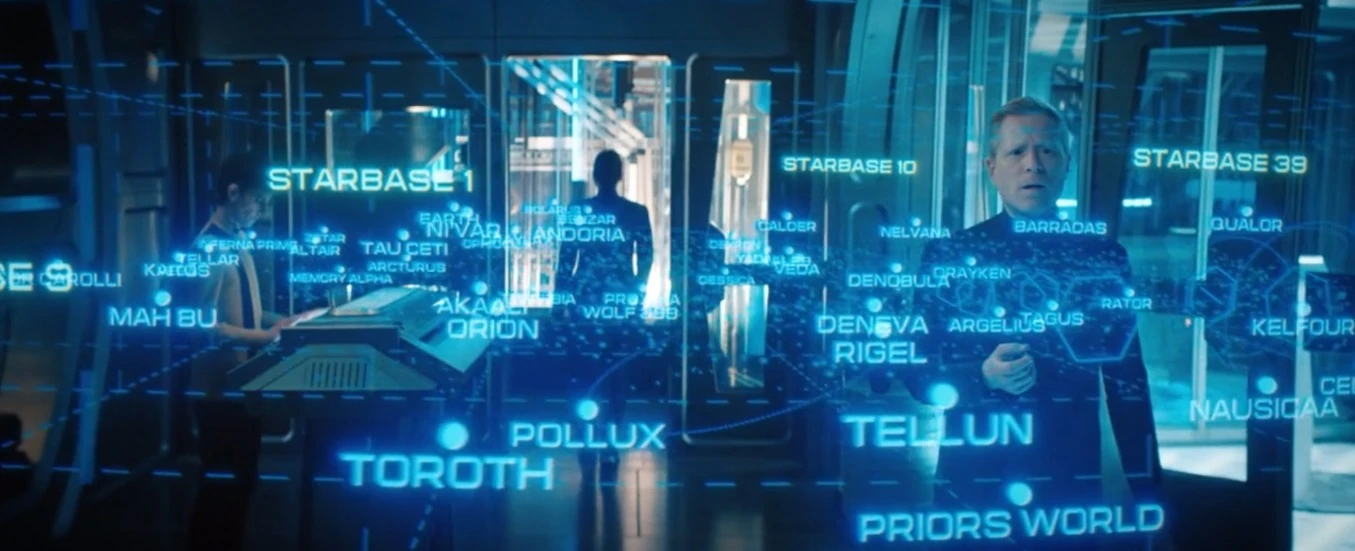
In 2259, the location of this system was labeled on a stellar cartography chart seen in the USS Enterprise's ready room viewscreen. The system's symbol had a blue color, indicating that it had an affiliation with the United Federation of Planets. (SNW: "Spock Amok", "A Quality of Mercy")
On stardate 1292.4, the location of this system was labeled on a star chart used during a Section 31 Alpha Team briefing. (Star Trek: Section 31)
The system's location was labeled in a Federation star chart that was in Fleet Admiral Kirsten Clancy's office at Starfleet Headquarters in 2399 and on the bridge of the USS Titan-A in 2401. Calder was in or near to space claimed by the Romulan Free State. (PIC: "Maps and Legends", "The Next Generation", "Disengage")
In 2401, the location of Calder was labeled on a star chart that was seen on the USS Stargazer's bridge viewscreen. The chart was used to show the location of the combined Starfleet-Borg armada and where it needed to go to face a galactic-level threat. (PIC: "Farewell")
Later that year, this system's position was labeled on a star chart used by Captain William T. Riker during his attempt at finding the last known location of the SS Eleos XII. (PIC: "The Next Generation")
Location of Calder labeled on a star chart (3190)
In 3190, the location of Calder was labeled on a star chart used by Commander Paul Stamets for tracking the movement of the Dark Matter Anomaly through the galaxy. (DIS: "The Examples")
In 3196, this system's position was labeled on a Federation star chart which was displayed on the main viewscreen of the USS Athena bridge. Systems affiliated with the Federation, including this one, had blue labels. (SA: "Ko'Zeine")
Later that year, during the Omega-47 crisis, the location of Calder was depicted on star charts and readouts used across several locations on the USS Athena to locate, monitor, and respond to the Omega-47 mines laid by the Venari Ral. (SA: "300th Night", "Rubincon")
External link
- Calder at Memory Beta, the wiki for licensed Star Trek works